Worlds, Biomes & Scientific Presets
Evolution models spatial ecology across a 169-hex (map_radius = 7) pointy-top axial hexagonal grid (HexMath, EvoTypes.HexCell) where elevation, temperature, humidity, seasonal oscillations, rural hinterland cultivation (crops and pasture), and glacial sea-level cycles govern local carrying capacity (\(K\)), available biomass (\(R\)), and movement barriers.
Rather than relying on random unstructured noise, the simulator ships with three Scientific World Presets (EvoPresets) designed to test foundational hypotheses in evolutionary biology, human paleoecology, insular biogeography, urban-rural co-evolution, and evolutionary game theory.
Hexagonal Grid Geometry & 1-Deme-Per-Hex Exclusivity (HexMath)
Every world is a pointy-top hexagonal spiral centered at axial coordinate \((q, r) = (0, 0)\) with cube constraint \(s = -q - r\) (\(q + r + s = 0\)).
Coordinate System, 169-Hex Scale & Single-Deme Footprint
- Hex Cell Identifier: Stored as
"%d,%d" % [q, r](e.g.,"0,0","-2,1","2,-1"). - Spiral Generation (
HexMath.generate_hex_spiral(radius)): Iterates over \(q \in [-R, +R]\) and \(r \in [\max(-R, -q - R), \min(R, -q + R)]\). The total number of hexagonal cells for map radius \(R\) is: $\(N_{\text{cells}}(R) = 1 + 3R(R + 1)\)$ - \(R = 7\) (All 3 Scientific Presets — The Rift Valley, Darwin's Archipelago, and The Finite Island): \(169\) hexagons
- Axial Distance (
HexMath.hex_distance): $\(d\big((q_1, r_1), (q_2, r_2)\big) = \left\lfloor \frac{|q_1 - q_2| + |r_1 - r_2| + |(-q_1 - r_1) - (-q_2 - r_2)|}{2} \right\rfloor\)$ - 6 Axial Neighbor Directions (
HexMath.DIRECTIONS): $\(\big[(+1, 0),\ (+1, -1),\ (0, -1),\ (-1, 0),\ (-1, +1),\ (0, +1)\big]\)$ Neighbor lookups (HexMath.get_neighbor_ids) are memoized in_neighbor_caches_by_sizeusing the collision-free coordinate hash \((q + 16) \times 32 + (r + 16)\) (supportingmap_radius <= 15). - Pointy-Top World Plane Projection (
HexMath.axial_to_world, \(\text{HEX\_SIZE} = 240.0\)): $\(x = 240.0 \cdot \sqrt{3} \cdot (q + 0.5r), \qquad y = 240.0 \cdot 1.5 \cdot r\)$ - Single-Deme-Per-Hex Exclusivity (
cell.deme_ids.size() <= 1): Every habitable hex cell supports at most one resident deme (cell.deme_ids.size() <= 1).HexMath.compute_village_sector_offsetalways returnsVector2.ZERO, giving every settlement the full \(240\text{-px}\) radial footprint of its hexagon for its 4-tier urban architecture (I · Camp\(\to\)IV · Metropolis), hex-edge perimeter walls (wall_r = 0.78), and animated villagers. All cooperation, trade, Hawk-Dove competition, raids, wars, rural hinterland cultivation, and synoecism occur across adjacent hex edges.
The 7 Biomes, Rural Land Use & Climate Defaults
Each HexCell stores its active biome, temperature (\([-1.0, +1.0]\)), humidity (\([0.0, +1.0]\)), altitude (\([0.0, +1.0]\)), current biomass current_resources (\(R\)), current carrying_capacity (\(K\)), undamaged ceiling carrying_capacity_max (\(K_{\max}\)), seasonal_regen_rate (\(r_{\text{regen}}\)), rural land_use ("wild" | "crops" | "pasture"), owner_deme_id, and persistent has_ruins flag.
The baseline biophysical parameters defined in EvoTypes.BIOME_CLIMATE_DEFAULTS are:
| Biome ID | Display Name (EN / ES) | Temp (\(T\)) | Humidity (\(H\)) | Altitude Range (min–max) |
Seasonal Regen (\(r_{\text{regen}}\)) | Base \(K_{\max}\) | Ecological Role & Rural Land-Use Conversion |
|---|---|---|---|---|---|---|---|
tropical_forest |
Tropical Forest / Bosque Tropical | +0.45 |
0.85 |
0.28 – 0.65 |
0.28 |
600.0 |
High-biomass, high-regeneration sanctuary; converts to golden agricultural "crops" when claimed as a rural hinterland. |
savanna |
Savanna / Sabana | +0.50 |
0.40 |
0.28 – 0.65 |
0.18 |
420.0 |
Intermediate seasonal mosaic; rewards food storage, cooperation, and converts to "crops" when cultivated by an adjacent settlement. |
arid_steppe |
Arid Steppe / Estepa Árida | +0.65 |
0.20 |
0.30 – 0.70 |
0.12 |
280.0 |
Water-stressed scrubland; converts to fenced livestock "pasture" (pasture_pen & granary) when claimed as a rural hinterland. |
tundra |
Tundra / Tundra | -0.55 |
0.35 |
0.35 – 0.74 |
0.10 |
240.0 |
Sub-zero boreal habitat; imposes thermal metabolic costs and converts to pastoral "pasture" when claimed by an adjacent town. |
high_mountain |
High Mountain / Alta Montaña | -0.40 |
0.25 |
0.78 – 0.98 |
0.08 |
140.0 |
Tectonic barrier ridge. Traversable only when \(\text{altitude} \le 0.85\) and \((\text{altitude} - 0.50) \le v_{\text{eff}}.\text{spatial\_mobility}\); cannot be claimed as rural farmland. |
coastal_shallows |
Coastal Shallows / Bajíos Costeros | +0.20 |
0.70 |
0.14 – 0.24 |
0.20 |
260.0 |
Intertidal land bridges (alt = 0.18 in Darwin's Archipelago) that periodically emerge and flood with sea-level changes; converts to "crops" when exposed and claimed. |
ocean |
Ocean / Océano | +0.10 |
0.90 |
0.02 – 0.08 |
0.02 |
50.0 |
Deep marine barrier (\(R = 0.0\)). Impassable to terrestrial demes; submergence displaces or extinguishes resident populations. |
Passability & Barrier Traversal Formula
Whether a deme can migrate into, claim rural hinterlands in, or maintain genetic contact across an adjacent hexagon ncell is governed by EvoDemographyMigration.is_hex_passable_for_deme(ncell, spatial_mobility):
Tectonic Ridges & Mountain Passes
In The Rift Valley, the central mountain ridge (q == 0) has altitude = 0.88 > 0.85 except at three natural savanna mountain passes at (0, -3), (0, 0), and (0, 3) (altitude = 0.52), forcing populations to funnel through the passes, carve new corridors with the Valley Pickaxe (-0.18 altitude), or evolve in geographic isolation.
Dynamic Environmental Cycles (EvoEnvPhase)
At the start of every generation (EvoEnvPhase.run_environmental_phase), the physical world evolves through four deterministic environmental mechanisms:
flowchart TD
    Gen["Advance Generation (t → t + 1)\nFlip Season: wet_warm ↔ dry_cold"] --> Glacial{"Glacial Cycle Active\n& (t % 8 == 0)?"}
    Glacial -- "Yes" --> SeaToggle["Toggle Sea Level:\n0.12 (Low Tide) ↔ 0.25 (High Tide)"]
    Glacial -- "No" --> FloodCheck["Evaluate Coastal Elevation vs. sea_level"]
    SeaToggle --> FloodCheck
    FloodCheck --> Submerge["alt < sea_level → biome = 'ocean'\nClear land_use / owner_deme_id\nDisplace Deme to Empty Neighbor or Drown"]
    FloodCheck --> Emerge["alt >= sea_level (was ocean) → Emerge Land\ncoastal_shallows / savanna / steppe / mountain"]
    Submerge & Emerge --> Regen["Oscillate Cell Temp (±0.04) & Humidity (±0.05)\nRecover K (+5% or +0.5% if Collapsed)\nRegenerate Biomass R = min(K, R + K · r_regen · γ_season)"]
1. Seasonal Oscillation (wet_warm \(\leftrightarrow\) dry_cold)
Every generation alternates between Warm Spring (wet_warm) and Dry Winter (dry_cold):
- Seasonal Biomass Multiplier (\(\gamma_{\text{season}}\)): $\(\gamma_{\text{season}} = \begin{cases} 1.20 & \text{if } \text{season} = \text{"wet\_warm"} \\ 0.75 & \text{if } \text{season} = \text{"dry\_cold"} \end{cases}\)$
- Thermal & Hydric Drift: Every non-ocean hex shifts by \(\Delta T = \pm 0.04\) (clamped to \([-1.0, +1.0]\)) and \(\Delta H = \pm 0.05\) (clamped to \([0.0, +1.0]\)).
2. Glacial Sea-Level Cycles & Land Bridges
When state.glacial_sea_level_cycle == true (active by default in preset-darwin-archipelago), global sea level oscillates every 8 generations:
- Generations
1–7:sea_level = 0.12— the 7 coastal shallows (altitude = 0.18) remain passable land bridges. - Generations
8–15:sea_level = 0.25— coastal shallows flood intoocean, isolating outer island populations for 8 consecutive turns. - Generations
16–23:sea_level = 0.12— land bridges re-emerge ascoastal_shallowswith \(K_{\max} = \max(160.0, K_{\max})\), \(K = \max(\text{round}(0.88 \cdot K_{\max}), K)\), and \(R = \max(R, \text{round}(0.35 \cdot K))\).
3. Coastal Submergence & 1-Deme-Per-Hex Relocation
Whenever a hex's altitude falls below state.sea_level (via glacial cycles or God-mode altitude/sea-level tools), it converts to "ocean", resets land_use = "wild", owner_deme_id = "", and has_ruins = false, and any resident deme must evacuate immediately:
- The engine scans all 6 adjacent neighbor hexes for valid empty refuges (
ncell.biome != "ocean",ncell.deme_ids.is_empty(),ncell.altitude <= 0.85, andncell.altitude - 0.50 <= v_eff.spatial_mobility), sorted by highestcurrent_resources(\(R\)). - Emergency Relocation: If an empty passable refuge exists, the deme relocates to the best neighbor (clearing any prior rural
owner_deme_id/land_useon that hex), suffers a \(10\%\) transit population loss and \(20\%\) energy reserve penalty (\(E_{\text{reserves}} \leftarrow 0.80 \cdot E_{\text{reserves}}\)), and generates a"migration"flow (intensity = 0.80). - Submergence Extinction: If all surrounding hexes are ocean, impassable peaks (
altitude > 0.85), or already occupied (deme_ids.size() >= 1), the deme drowns—recording an"extinction"entry in the Chronicle and releasing any rural hinterlands it owned intohas_ruins = true.
4. Passive Carrying Capacity (\(K\)) & Biomass (\(R\)) Regeneration
Each non-ocean cell recovers its carrying capacity \(K\) toward \(K_{\max}\) and replenishes available food \(R\):
Deep-Dive: The 3 Scientific World Presets (169 Hexes) & 1v1 Strategy Matchups
Every preset world (EvoPresets.create_preset_world(preset_id, lang, strategy_a_id, strategy_b_id)) initializes a balanced 1v1 Evolutionary Strategy Duel between Founder A (state.strategy_a_id) and Founder B (state.strategy_b_id) on a 169-hex (map_radius = 7) map. By default, strategy_a_id is strat-cooperation (🤝 Cooperative Alliance, #10B981) and strategy_b_id is strat-war (⚔️ Conquering Horde, #EF4444), and players can switch either slot to any of the 5 base archetypes or custom user strategies (~/.config/Evolution/user_catalog.json) via the Top HUD Matchup Bar at Generation 0.
1. The Rift Valley (preset-rift-savanna)
Scientific Hypothesis: East Side Story / Tectonic Savanna Hypothesis — How tectonic uplift and eastern rain-shadow aridification pit a western rainforest population (Strategy A) against an eastern savanna-steppe population (Strategy B) separated by a high-mountain ridge pierced by three mountain passes.
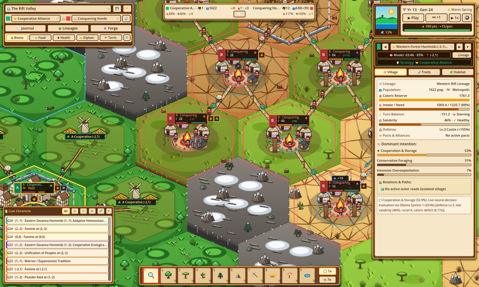
- Map Geometry: Radius \(R = 7\) (\(169\) hexes),
sea_level = 0.12,glacial_sea_level_cycle = false. - Topographic Partition:
| Region | Axial Condition | Biome | Temp | Humidity | Altitude | Initial \(R\) | Initial \(K\) | \(K_{\max}\) | Regen \(r_{\text{regen}}\) |
| :--- | :--- | :--- | :---: | :---: | :---: | :---: | :---: | :---: | :---: |
| Western Basin | \(q < 0\) (77 hexes) |
tropical_forest|+0.45|0.85|0.35|560.0|600.0|650.0|0.30| | 3 Mountain Passes | \(q = 0,\ r \in \{-3, 0, +3\}\) (3 hexes) |savanna|+0.25|0.45|0.52|240.0|280.0|320.0|0.18| | Tectonic Ridge | \(q = 0,\ r \notin \{-3, 0, +3\}\) (12 hexes) |high_mountain|-0.35|0.25|0.88|70.0|108.0|120.0|0.08| | Eastern Mosaic (Odd) | \(q > 0,\ |q+r| \bmod 2 = 1\) (39 hexes) |savanna|+0.60|0.30|0.42|260.0|335.0|380.0|0.16| | Eastern Mosaic (Even) | \(q > 0,\ |q+r| \bmod 2 = 0\) (38 hexes) |arid_steppe|+0.60|0.30|0.42|260.0|335.0|380.0|0.16| - 1v1 Founding Lineages & Subpopulations:
| Slot | Deme ID & Name (EN / ES) | Lineage ID & Name (EN / ES) | Founder Hex | Initial Pop | Reserves | \(\Delta E_0\) | Assigned Strategy | System 1 Model |
| :---: | :--- | :--- | :---: | :---: | :---: | :---: | :---: | :---: |
| Strategy A |
deme-rift-west
Western Forest Hominids
Homínidos del Bosque Occidental |lineage-rift-west
Western Rift Lineage
Linaje Occidental del Rift |-2,1
(tropical_forest) |140|180.0|+12.0|state.strategy_a_id
(Default:strat-cooperation🤝) |d3:4b| | Strategy B |deme-rift-east
Eastern Savanna Hominids
Homínidos de la Sabana Oriental |lineage-rift-east
Eastern Rift Lineage
Linaje Oriental del Rift |2,-1
(arid_steppe) |140|180.0|+8.0|state.strategy_b_id
(Default:strat-war⚔️) |tev1:4b| - Evolutionary & Urban Dynamics:
- Western Forest Hominids (
-2,1) begin at Tier II (pop = 140) in high-biomasstropical_forest(\(R = 560, K = 600\)), rapidly cultivating adjacent"crops"hinterlands and expanding across the western basin. - Eastern Savanna Hominids (
2,-1) begin at Tier II (pop = 140) in the eastern mosaic, cultivating mixed"crops"(savanna) and"pasture"(arid steppe) hinterlands while navigating seasonal scarcity, mountain passes ((0,-3),(0,0),(0,3)), Baldwin genetic assimilation, Cumulative Cultural Innovation, and Allopatric Speciation.
2. Darwin's Archipelago (preset-darwin-archipelago)
Scientific Hypothesis: Insular Biogeography & Allopatric Speciation — How glacial eustatic sea-level oscillations alternately connect volcanic islands via 7 temporary land bridges (
coastal_shallows) and isolate rival colonizing founder strategies across contrasting thermal niches.
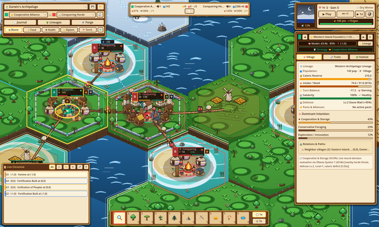
- Map Geometry: Radius \(R = 7\) (\(169\) hexes),
sea_level = 0.12,glacial_sea_level_cycle = true(toggles0.12\(\leftrightarrow\)0.25every 8 generations). - Archipelago Layout:
| Island / Feature | Hex Coordinates | Biome | Temp | Humidity | Altitude | Initial \(R\) | Initial \(K\) | \(K_{\max}\) | Regen \(r_{\text{regen}}\) |
| :--- | :--- | :--- | :---: | :---: | :---: | :---: | :---: | :---: | :---: |
| Central Hub Island |
0,0(1 hex) |tropical_forest|+0.20|0.75|0.40|320.0|395.0|450.0|0.24| | Central Duel Islands |-1,0,1,0,-2,0,-1,-1,2,-1,1,1(6 hexes) |tropical_forest|+0.22|0.75|0.65|220.0|220.0|220.0|0.24| | 7 Tidal Land Bridges |0,-1,0,1,2,0,-2,1,0,-4,0,4,4,-1(7 hexes) |coastal_shallows|+0.15|0.65|0.18|200.0|230.0|260.0|0.22| | Northern Boreal Chain |0,-2,0,-3,1,-2,-1,-2,1,-3,0,-5,1,-4(7 hexes) |tundra|-0.55|0.40|0.55|360.0|380.0|420.0|0.24| | Southern Tropical Chain |0,2,0,3,-1,2,1,2,-1,3,0,5,-1,4(7 hexes) |tropical_forest|+0.55|0.85|0.45|420.0|450.0|500.0|0.28| | Eastern Xeric Chain |3,0,3,-1,4,0,3,1,4,-2,5,-1(6 hexes) |arid_steppe|+0.65|0.25|0.45|330.0|360.0|400.0|0.22| | Surrounding Deep Sea | Remaining 135 hexes |ocean|+0.10|0.90|0.05|0.0|20.0|60.0|0.05| - 1v1 Founding Lineages & Subpopulations:
| Slot | Deme ID & Name (EN / ES) | Lineage ID & Name (EN / ES) | Founder Hex | Initial Pop | Reserves | \(\Delta E_0\) | Assigned Strategy | System 1 Model |
| :---: | :--- | :--- | :---: | :---: | :---: | :---: | :---: | :---: |
| Strategy A |
deme-darwin-founder
Western Island Founders
Fundadores Insulares del Oeste |lineage-darwin-a
Western Archipelago Lineage
Linaje Occidental del Archipiélago |-1,0
(tropical_forest) |95|165.0|+12.0|state.strategy_a_id
(Default:strat-cooperation🤝) |d3:4b| | Strategy B |deme-darwin-rival
Eastern Island Rivals
Rivales Insulares del Este |lineage-darwin-b
Eastern Archipelago Lineage
Linaje Oriental del Archipiélago |1,0
(tropical_forest) |95|165.0|+10.0|state.strategy_b_id
(Default:strat-war⚔️) |tev1:4b| - Evolutionary Dynamics:
- Both rival founders begin on symmetric high-ground island perches (
-1,0and1,0,K = 220) flanking the central hub(0, 0). - During Generations 1–7 (low tide,
sea_level = 0.12), exposed coastal land bridges (0,-1,0,1,2,0,-2,1,0,-4,0,4,4,-1) allow budding daughter demes from both strategies to race across the central hub onto the outer Tundra, Southern Tropical, and Eastern Arid Steppe island chains. - At Generation 8,
sea_levelrises to0.25, submerging all 7 land bridges (altitude = 0.18 < 0.25) intoocean. Any deme standing on a bridge evacuates to an empty adjacent island hex or drowns, and isolated island colonies accumulateisolation_turnsuntil reaching \(\ge 10\) turns and diverging via Allopatric Speciation into new child species inlineage_tree(while retaining their parentstrategy_id).
3. The Finite Island (preset-finite-island)
Scientific Hypothesis: The Tragedy of the Commons & Cultural Stewardship — How two competing clans sharing a bounded island ecosystem with slow biomass regeneration (\(r_{\text{regen}} = 0.08\)) either exhaust their carrying capacity \(K\) through intensive overexploitation and Hawk-Dove conflict, or stabilize via Communal Conservation Norms, rural hinterland stewardship, and Reciprocal Symbiosis.
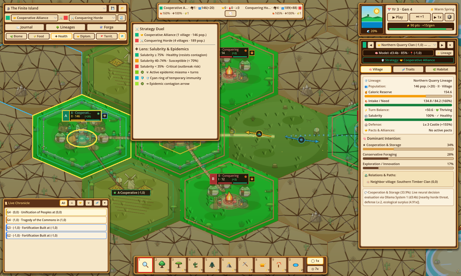
- Map Geometry: Radius \(R = 7\) (\(169\) hexes),
sea_level = 0.20,glacial_sea_level_cycle = false. - Concentric Island Rings (by axial distance \(d = \text{hex\_distance}(0, 0, q, r)\)):
| Ring | Distance \(d\) | Biome | Temp | Humidity | Altitude | Initial \(R\) | Initial \(K\) | \(K_{\max}\) | Regen \(r_{\text{regen}}\) |
| :--- | :---: | :--- | :---: | :---: | :---: | :---: | :---: | :---: | :---: |
| Fertile Core | \(d \le 1\) (7 hexes) |
savanna|+0.30|0.55|0.42|580.0|600.0|600.0|0.08| | Steppe Interior & Coast | \(2 \le d \le 3\) (30 hexes) |arid_steppe|+0.45|0.30|0.48|220.0|270.0|300.0|0.08| | Outer Shallows Reefs | \(d = 4,\ |q-r| \bmod 2 = 0\) (12 hexes) |coastal_shallows|+0.22|0.65|0.22|180.0|220.0|260.0|0.14| | Abyssal Ocean | Remaining 120 hexes |ocean|+0.15|0.90|0.05|0.0|20.0|60.0|0.05| - 1v1 Founding Lineages & Clans:
| Slot | Deme ID & Clan Name (EN / ES) | Lineage ID & Name (EN / ES) | Founder Hex | Initial Pop | Reserves | \(\Delta E_0\) | Assigned Strategy | System 1 Model |
| :---: | :--- | :--- | :---: | :---: | :---: | :---: | :---: | :---: |
| Strategy A |
deme-island-1
Northern Quarry Clan
Clan de la Cantera Norte |lineage-island-1
Northern Quarry Lineage
Linaje de la Cantera Norte |-1,0
(savanna) |95|140.0|+8.0|state.strategy_a_id
(Default:strat-cooperation🤝) |d3:4b| | Strategy B |deme-island-2
Southern Timber Clan
Clan Maderero del Sur |lineage-island-2
Southern Timber Lineage
Linaje Maderero del Sur |1,0
(savanna) |95|140.0|+8.0|state.strategy_b_id
(Default:strat-war⚔️) |tev1:4b| - Evolutionary Dynamics:
- Northern Quarry Clan (
-1,0, Strategy A) and Southern Timber Clan (1,0, Strategy B) start on opposite sides of the fertile savanna core (\(d \le 1\), where natural regeneration is constrained to \(r_{\text{regen}} = 0.08\)). - When an extractive or martial strategy (
strat-war⚔️ orstrat-innovation🔬 carryingcul-extraction-toolswithoutcul-communal-conservation) expands across the island, intensive harvesting degrades \(K\) by \(18\% \cdot \sum v_{\text{eff}}.\text{ecological\_impact}\) per turn until \(K < 0.60 \cdot K_{\max}\) triggers the Tragedy of the Commons—whereas cooperative or mercantile strategies (strat-cooperation🤝,strat-trade⚖️) preserve \(K\), maintain urbansalubrity, and build symbiotic trade networks and multi-hex walled unions.